Custom Correct
The Brothers - Mt Anderson Trail Map
The Brothers - Mt Anderson Trail Map
Couldn't load pickup availability
Share
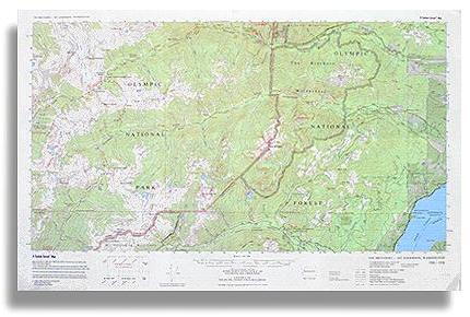
The Brothers - Mt. Anderson Trail Map by Custom Correct is an essential companion for exploring the rugged backcountry of the Olympic Mountains. Centered on The Brothers Wilderness within Olympic National Forest, this detailed map extends into the Olympic National Park, covering the remote Duckabush and West Fork Dosewallips valleys.
It highlights the dramatic Mount Anderson Massif, a key triple divide of the range, along with high-country trails threading through the headwaters of the East Fork Quinault, West Fork Dosewallips, Duckabush, Hamma Hamma, and North Fork Skokomish Rivers.
With a precise 1:62,500 scale (1 inch to the mile) and 100-foot contour intervals, it provides accurate terrain representation for hikers, backpackers, and climbers navigating this wild and scenic landscape.
Available in paper or laminated versions. The laminate is thin so it is easily foldable.
SKU: SKU:LRETB-MA
View full details