1
/
of
1
Green Trails
Santa Rita Mountains, AZ- Green Trails Map 2962S
Santa Rita Mountains, AZ- Green Trails Map 2962S
Regular price
$14.00 USD
Regular price
Sale price
$14.00 USD
Unit price
/
per
Couldn't load pickup availability
Share
Santa Rita Mountains, AZ - Green Trails Map 2962s
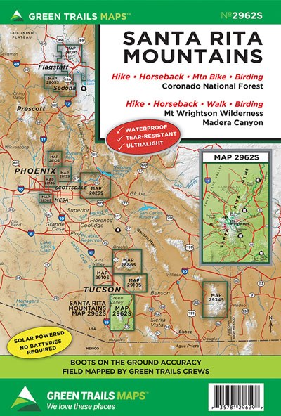
With a relief of more than 7,000 feet and a distinct pyramidal shape, Mount Wrightson in the Santa Rita Mountains is a prominent landmark in southern Arizona. At 9,453-feet, it is the highest mountain in the Tucson Area. A network of trails traverse its rocky, chaparral, and forested slopes and lead to stunning and sweeping viewpoints. Our 2962S Map covers the entire 25,260-acre Mount Wrightson Wilderness area along with the adjacent Madera Canyon area known for its outstanding birdwatching with more than 250 recorded species. This map incudes a close-up inset (1:26,000 scale) of the canyon and the Mount Wrightson summit area. Map also includes the Arizona Trail from Redrock Canyon near Patagonia to Twin Tanks. The Patagonia-Sonoita Nature Conservancy Preserve trails are also shown on this map.
Original Edition 2017, Current Edition 2022
Printed on a rugged Waterproof - Tear Resistant Sheet.
Map Scale 1:62,000.
SKU: SKU:GRE2962S
View full details