Custom Correct
Quinault - Colonel Bob Trail Map
Quinault - Colonel Bob Trail Map
Couldn't load pickup availability
Share
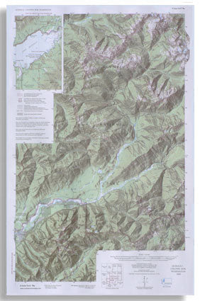
The Quinault - Colonel Bob Trail Map by Custom Correct is an exceptional guide to the Olympic Mountains in Washington State. The map showcases the North Fork of the Quinault River, the Skyline Trail, and the Colonel Bob Wilderness, all within Olympic National Park and Olympic National Forest.
The map features stunning three-dimensional shaded relief, adding depth to the terrain. It covers the full extent of the North Fork Quinault and Skyline Trail Systems, including Low Divide, as well as the Colonel Bob Wilderness and all its trails—an invaluable resource for hikers.
Additional details include campgrounds, nature trails around Lake Quinault, and roads leading to North Fork and Graves Creek.
Scale 1:62,500, contour interval 80 feet.
SKU: SKU:LREQ-CB
View full details