Custom Correct
Queets Valley Trail Map
Queets Valley Trail Map
Couldn't load pickup availability
Share
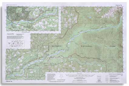
The Queets Valley Trail Map by Custom Correct is your guide to exploring the secluded beauty of Olympic National Park’s Queets River corridor. This topo map covers the entire Queets River trail system, stretching from the campground at the end of the road to three miles beyond the trail’s end.
It also highlights the surrounding Olympic National Forest and State Forest Land, offering an unparalleled opportunity for rain forest solitude in the park’s most isolated region. For river enthusiasts, the map extends down to the confluence of the Queets and Clearwater Rivers, detailing boat ramps and road access points.
With a scale of 1:62,500 and an 80-foot contour interval, this map ensures accurate navigation of one of Washington’s most remote and stunning natural areas.
SKU: SKU:LREQV
View full details