1
/
of
1
USGS
North America Shaded Relief Map
North America Shaded Relief Map
Regular price
$18.00 USD
Regular price
Sale price
$18.00 USD
Unit price
/
per
Couldn't load pickup availability
Share
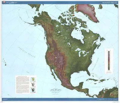
This map uses transitioning shades of green, brown, and mauve to represent elevation levels in North America. A shaded relief effect is achieved by transforming digital data to simulate sun illumination at a 45 degree level above the horizon shining from a northwest perspective. The shading visually realistic with darker tones representing steeping slopes on the land. Country names are labeled. Each of the fifty United States is outlined in black and labeled. Printed in 1999.
Size: 43" x 39" Scale: 1:10,000,000
SKU: SKU:USG5682
View full details