WoodChart
Manhattan, NY 3D Nautical Wood Chart
Manhattan, NY 3D Nautical Wood Chart
Couldn't load pickup availability
Share
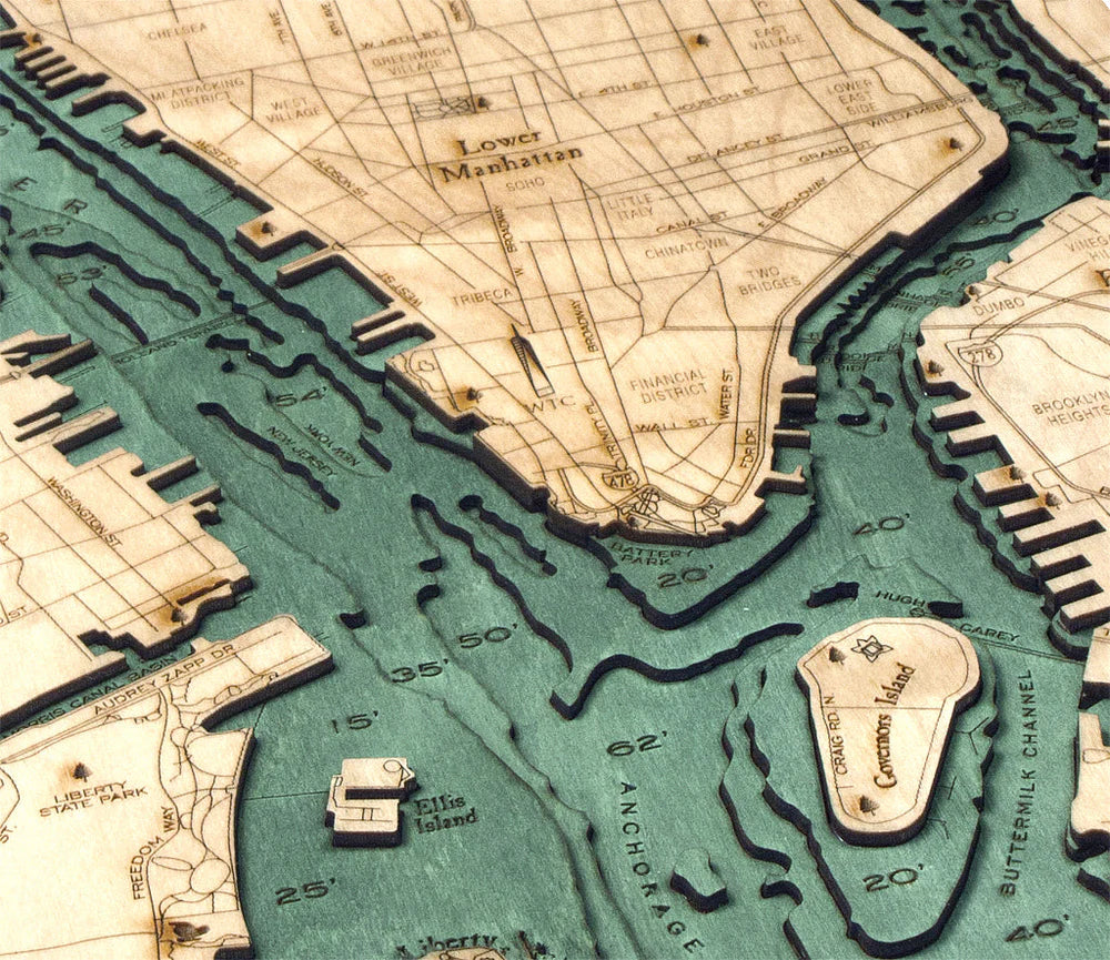
Celebrate the iconic heart of New York with this beautifully crafted Manhattan, NY 3D Nautical Wood Chart, a striking wall piece that blends art, geography, and maritime history. Surrounded by the powerful currents of the Hudson River, East River, and Harlem River, Manhattan has long been shaped by its waterways. These tidal channels helped transform New York City into one of the world’s most important ports. In fact, the island’s natural harbor and strategic Atlantic location fueled its rise as a global center for commerce and immigration, especially during the 19th and early 20th centuries when millions arrived through nearby Ellis Island.
Manhattan’s narrow island geography—roughly 13 miles long and just over 2 miles wide—makes it uniquely suited for a nautical-style map. The surrounding waters, once navigated by Lenape canoes and later by Dutch trading ships, are brought to life through layered wood contours that reflect real bathymetric depth data. The result is a dimensional coastal map that highlights both the island’s shoreline and the vibrant cityscape built upon it.
Manhattan, NY 3D Nautical Wood Chart points of interest include: Central Park, Times Square, Grand Central Terminal, Wall Street and the Financial District, Rockefeller Center, the Upper East Side, Upper West Side, Harlem, Lower East Side, SoHo, West Village, East Village, Little Italy, and Chinatown. Central Park, the city’s famous 843-acre green oasis, was completed in 1876 and remains one of the most visited urban parks in the world. Wall Street marks the birthplace of the modern American financial system and traces its name back to a 17th-century defensive wall built by Dutch settlers. Meanwhile, the dazzling lights of Times Square earned it the nickname “The Crossroads of the World.”
Manhattan, NY 3D Nautical Wood Chart color options: Choose between a Dark Brown Frame with Greenish Blue Water for a rich, classic nautical aesthetic, or a Rustic Grey Frame with Greyish Blue Water that offers a cooler, coastal-inspired tone perfect for modern décor.
Manhattan, NY 3D Nautical Wood Chart production process: Measuring 13.5" x 31", each chart begins with accurate bathymetric depth data used as the foundation for the design. An artist then laser-cuts premium birch wood into precisely shaped layers that represent the varying underwater contours. These layers are carefully stacked and bonded together to create a dimensional landscape. The surrounding water areas are hand-stained to enhance the depth effect, while place names, roads, landmarks, and depth markings are engraved directly into the wood surface. The finished map is enclosed in a custom-sized wooden frame and protected by a clear sheet of durable acrylic glass, creating a refined piece that’s both artistic and enduring.
SKU: SKU:MINMAN
View full details