Custom Correct
Hurricane Ridge Trail Map
Hurricane Ridge Trail Map
Couldn't load pickup availability
Share
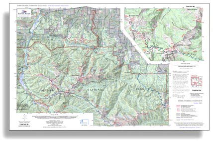
The Hurricane Ridge Trail Map by Custom Correct is essential for exploring the rugged beauty of Olympic National Park’s high country. Covering the stunning ridgelines and deep valleys from Obstruction Point to Port Angeles, this detailed topo map highlights key trails linking Hurricane Ridge to Heart O’ the Hills, Little River, the Elwha, and Deer Park. It features both high-country road access points—Hurricane Ridge and Deer Park—offering a gateway to breathtaking alpine adventures.
An inset provides a close-up view of the Hurricane Ridge Visitor Center and Ski Area, perfect for planning year-round activities. With a 1:62,500 scale and 100-foot contour intervals, this map delivers precision for hikers and backcountry explorers. Navigate the heart of Olympic National Park with confidence and discover the beauty of the North Olympic Mountains.
SKU: SKU:LREHR
View full details