1
/
of
1
Custom Correct
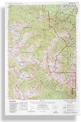
Gray Wolf - Dosewallips Trail Map
Gray Wolf - Dosewallips Trail Map
Regular price
$8.95 USD
Regular price
Sale price
$8.95 USD
Unit price
/
per
Couldn't load pickup availability
Share
The Gray Wolf - Dosewallips Trail Map by Custom Correct is a great guide to some of the remote and rugged landscapes of Olympic National Park and the Buckhorn Wilderness. Covering the headwaters of the Dungeness and Main Fork Dosewallips Rivers, this detailed topo map highlights an extensive network of high-country trails winding through the northeast Olympics. From Obstruction Point and Deer Park to the Dosewallips Road, it offers a clear view of the Gray Wolf Drainage, the upper Dungeness, and the stunningly isolated Royal Basin.
Ideal for backpackers and adventurers, the 1:62,500 scale provides precise navigation with 50-foot contour intervals, ensuring confidence in route planning. Whether exploring deep valleys or sweeping alpine ridges, this map is an indispensable companion for experiencing the wild beauty of Washington’s Olympic Mountains.
SKU: SKU:LREGW-D
View full details