1
/
of
1
Canadian Hydrographic Service (CHS)
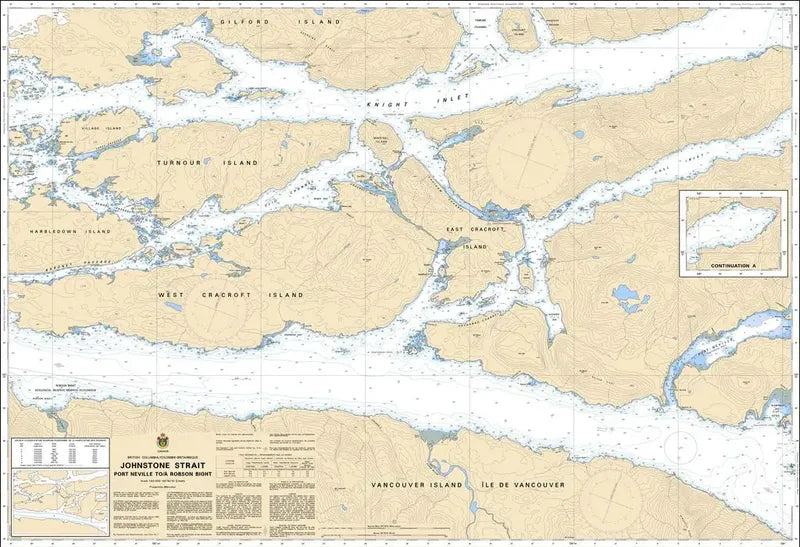
Canadian Chart 3545, Johnstone Strait, Port Neville to Robson Bight
Canadian Chart 3545, Johnstone Strait, Port Neville to Robson Bight
Regular price
$26.95 USD
Regular price
Sale price
$26.95 USD
Unit price
/
per
Couldn't load pickup availability
Share
Size/Scale: 44" x 31" | 1:40,000
The Canadian Hydrographic Service (CHS) is pivotal in ensuring the safety of navigation across Canada's waterways, providing indispensable nautical charts for mariners.
CHS Canadian Chart 3545 of Johnstone Strait Port Neville to Robson Bight stands out as a crucial resource, focusing on the intricate waterways of the Johnstone Strait Port Neville to Robson Bight area in British Columbia.
This official Canadian chart details key features such as Johnstone Strait, Port Neville to Robson Bight, Vancouver Island, West and East Cracroft Island, Turnour Island and more.
Renowned for its accuracy and reliability, CHS Canadian Chart 3545 Johnstone Strait Port Neville to Robson Bight serves as an indispensable tool for navigators.
Whether for recreational boating or commercial shipping, this chart offers essential information to enhance situational awareness and mitigate navigational risks in the region.
CHS's dedication to maritime safety is evident in the meticulous detail and usability of CHS Canadian Chart 3545, making it an essential companion for safe navigation in Canada's coastal waters.
Articles:
SKU: SKU:CHY3545
View full details