

Custom Correct
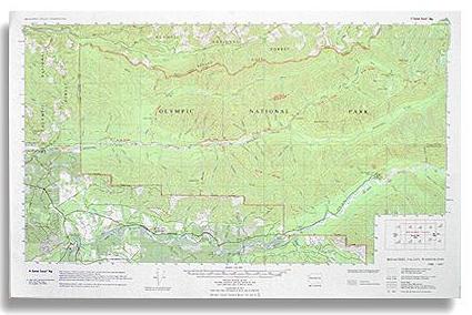
Bogachiel Valley Trail Map
Bogachiel Valley Trail Map
Couldn't load pickup availability
Share
The Bogachiel Valley Trail Map by Custom Correct covers the entire Bogachiel Rain Forest corridor within the Olympic National Park, and also details the middle Hoh River Valley in the northwest corner of the Olympic Mountains, along with portions of the surrounding Olympic National Forest.
This map includes the full length of the Bogachiel River Trail system, stretching from the Undi Road in the west to Mink Lake and Sol Duc Hot Springs in the east. It also highlights the middle Hoh River Valley, from Highway 101 to the Hoh Campground and trailhead, making it perfect for both backcountry adventurers and day hikers.
With a 1:62,500 scale and an 80-foot contour interval, this detailed map provides clear topographical information, ensuring you stay on course while navigating the deep valleys, towering ridges, and lush temperate rainforest of this spectacular region.
Available in paper or laminated versions. The laminate is thin so it is easily foldable.SKU: SKU:LREBV
View full details