WoodChart
Alaska 3D Nautical Wood Chart
Alaska 3D Nautical Wood Chart
Couldn't load pickup availability
Share
Alaska 3D Nautical Wood Chart Details:
- Made of high-quality birch
- Solid Wood Frame
- Acrylic Glass Protection
- Laser Cut Depth
- Engraved Place Names & Locations
- Arrives Ready to Hang
- 31" x 24.5"
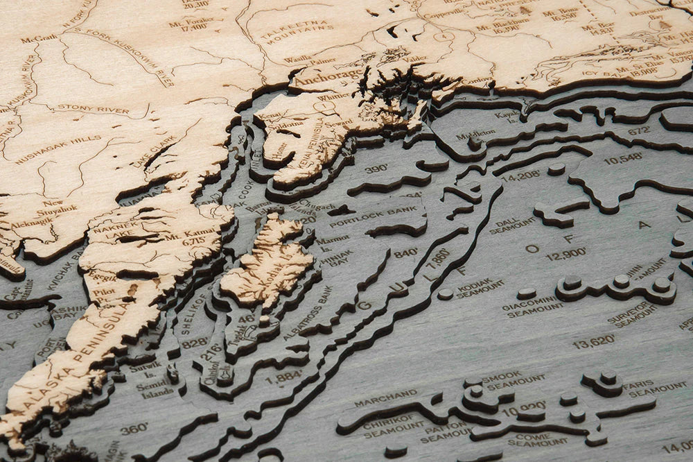
Celebrate the vast scale and rugged beauty of the Last Frontier with this Alaska 3D Nautical Wood Chart, a striking wall piece that brings the state’s legendary coastline and waterways to life. Alaska sits at the northwestern edge of North America, bordered by three major bodies of water and shaped by more coastline than the rest of the United States combined. From tide-carved fjords and island-studded passages to the open sweep of the Arctic and Pacific, this chart captures the dramatic meeting of land and sea that has guided Indigenous cultures, explorers, fishermen, and mariners for thousands of years.
The layered design reveals Alaska’s complex maritime geography, where the Gulf of Alaska fuels rich fisheries, the Bering Sea connects North America to Asia, and the Arctic Ocean defines the northernmost reaches of the continent. Historic routes of Russian traders, Gold Rush-era ports, and modern shipping lanes all trace the waters depicted here, offering a meaningful blend of geography and history in one refined display.
Alaska Wood Chart points of interest include: The Arctic Ocean, Anchorage, Bering Sea, Fairbanks, Gulf of Alaska, Juneau, Ketchikan, Nome, Unalaska, and Utqiagvik. These locations reflect Alaska’s extraordinary range, from remote Arctic communities and Interior hubs to iconic coastal cities shaped by fishing, trade, and exploration.
Alaska Nautical Wood Chart color options: Dark Brown Frame with Greenish Blue Water and Rustic Grey Frame with Greyish Blue Water. Each palette is designed to highlight depth contours while complementing both modern and rustic interiors.
Alaska 3D Nautical Wood Chart production process: This chart measures 31" x 24.5" and begins with detailed bathymetric data that defines underwater depths and contours. An artist precisely laser cuts premium birch wood into individual layers, which are carefully stacked and bonded to create a true sense of depth and dimension. The water areas are hand-stained for a natural, textured finish, while place names, notable locations, roads, and depth markings are engraved directly into the surface. The piece is completed with a custom-fitted wood frame and protected by durable acrylic glass, resulting in a museum-quality chart built to last.
Perfect for coastal homes, offices, or anyone drawn to Alaska’s untamed waters, this wood chart is both a work of art and a tribute to one of the world’s most extraordinary landscapes.
ArticlesSKU: SKU:MINALASKA
View full details