National Geographic
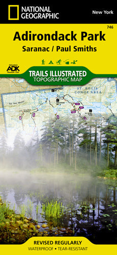
Adirondack Park (Saranac) Trails Illustrated Map #746
Adirondack Park (Saranac) Trails Illustrated Map #746
Couldn't load pickup availability
Share
Discover the wild charm of the Saranac Lakes region with National Geographic’s Adirondack Park (Saranac) Trails Illustrated Map #746. Whether you're paddling through the St. Regis Canoe Area, scaling Debar Mountain, or exploring the scenic stretches of the Racquette River, this map is your trusted guide to adventure. Covering key landmarks like Lake Placid, Carry Falls Reservoir, and the peaceful woodlands of Paul Smiths, the map is packed with up-to-date trail details and terrain insight.
Designed in collaboration with the Adirondack Mountain Club, it features a user-friendly trail chart for hikers, bikers, skiers, and snowmobilers alike. Trail mileage, elevation contours, campsites, fishing spots, and more are clearly marked to make trip planning a breeze. Printed on durable, waterproof paper with a full UTM grid for GPS use, this map is ready for anything—rain, snow, or sunshine. Whether you're heading out for a weekend or a week, this map helps you find your perfect route.
SKU: SKU:TRA746
View full details